Picking up and measuring rocks, flow, canopy cover, or water quality at each and every site is the stuff you have to do while you’d rather be catching fish. Habitat data collection is not glamorous but is often the most important part of field work. Yet when you are only measuring micro-habitat parameters at each site your dataset is limited to only places you have been to. Even if you successfully develop a habitat model with this data, you will lack data for the stream segments you have not yet sampled and will be unable to predict whether or not your study species will occur there. Although at times the Upper Clinch watershed seems small enough that Aaron Rodgers might be able to throw a football from one boundary to the other, amazing gradients of landscape level habitat conditions still exist. It remains too large an area to exhaustively sample by yourself. Luckily, the United States Geological Survey maintains files and files of habitat variables that are available for catchments (or small pieces of a larger watershed) all across the country. Each catchment and stream segment in the stream network has its own unique ComID number. Habitat data in NHDplus tables available for free online can easily be linked to their corresponding catchments in a GIS system. Mapping programs then allow you shade catchments based on the values of a particular variable, like those color by numbers coloring books you did as a kid. Interesting patterns begin to emerge that can help us learn about the system we study.
The following maps show the Upper Clinch River Watershed. No sampling record points are displayed on this map to ensure the protection of Clinch Dace populations. However, we can see that even within such a small area the diversity of habitats provides unique conditions preferred by individual species within this biodiversity hotspot.

This paneled figure shows the variation in surface geology throughout the region. A shows the proportion of each catchment that has colluvium or larger rocky substrate transported by gravitational processes. Colluvium is most common in the northern part of the basin. B shows the proportion of red clay which predominate in the agricultural southern part of the basin. And C shows the proportion of alluvial or floodplain soils that are concentrated along the mainstem Clinch River.

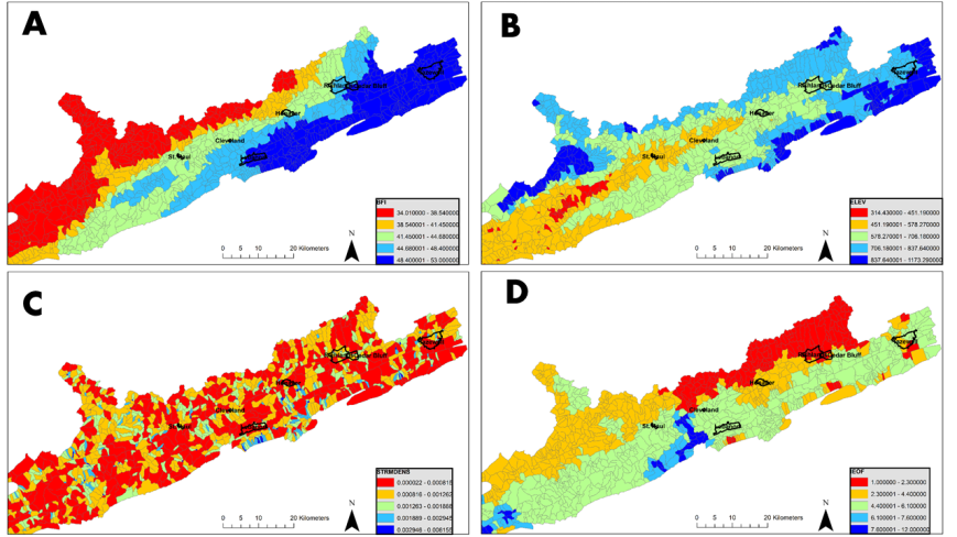
The panels of this second figure display different characteristics related to ground and surface water movement in each catchment. Panel A shows the base flow index which measures the relative influence of subsurface flow in each catchment. Groundwater contributions are highest in the eastern part of the watershed. Panel B shows the mean elevation in each catchment. Elevation is lowest in the middle of the watershed where the Clinch River valley lowlands lie. Elevation also has major effects on mean air temperature in each catchment. Panel C shows stream density or the length of stream divided by the area of the catchment. No clear geographic patterns emerge with stream density. Finally panel D represents the amount of precipitation infiltration versus surface runoff. It should not be surprising that in the clay dominated southern part of the watershed precipitation does not as readily infiltrate the soil.

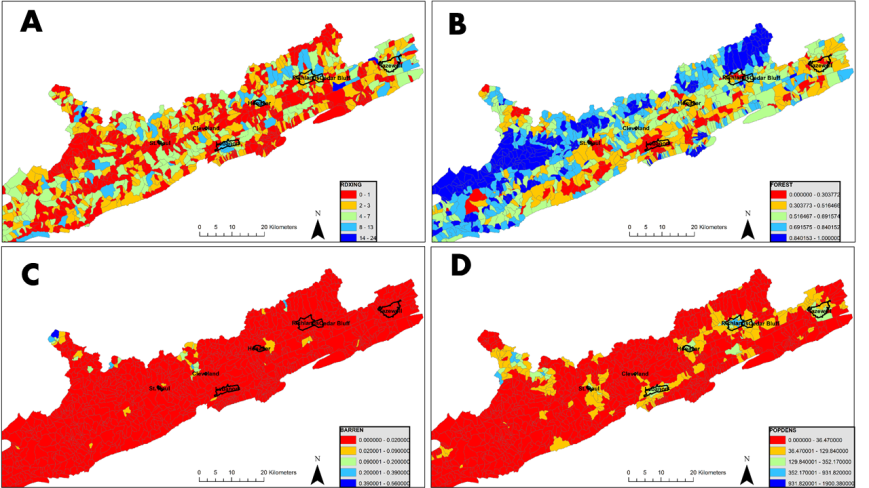
The final figure shows aspects of human impacts on the watershed. Panel A shows the number of times roads cross streams in each catchment. The number of road crossings is related to human population density shown in panel D and is at its lowest in areas of the Jefferson National Forest in Northern Scott Co. Figure B shows the proportion of each catchment that is forested. Northern catchments are more forested while southern catchments have largely been converted to agriculture and pasture. Panel C shows the proportion of each catchment that is barren rock. This may indicate that the catchment contains surface mines. The highest intensity of surface mining occurs near Cleveland, Northwest of Richlands, and in the peninsula in the northwest corner of the figure that is the Guest River watershed.
